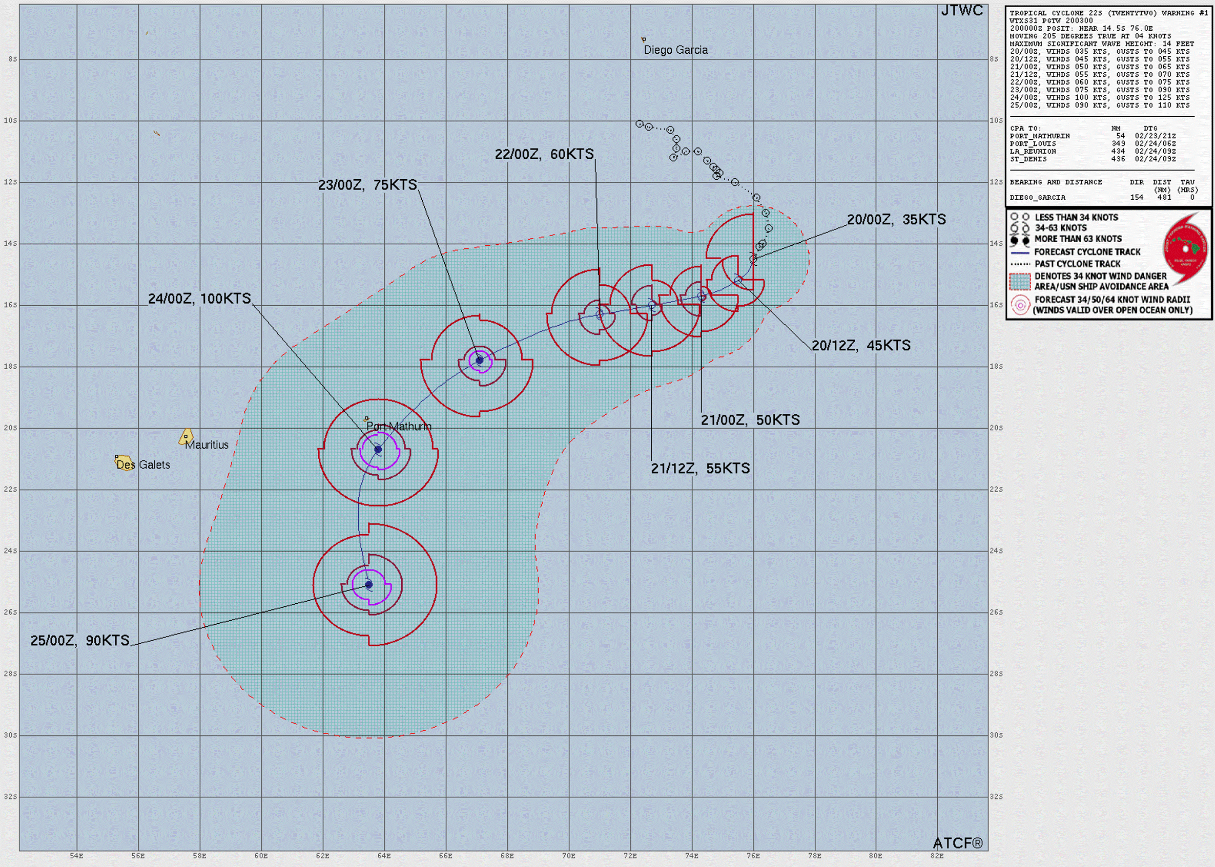
Current Storms:

Hurricane KIKO

Updated September 04, 2025 at 06:00 UTC

Located at 13.8°N, 132.6°W

Minimum Pressure: 944 mb

Maximum Winds: 125 kt

Radius of Maximum Wind: 10 nm

Environmental Pressure: 1014 mb

Storm Radius: 220 nm

Formerly Invest 93E

Current Conditions

Latest Satellite Image Latest satellite image for Hurricane KIKO
Wind RadiiWind radii for Hurricane KIKO
Sea Temperatures Sea surface temperature map for Hurricane KIKO
34/37 GHz Microwave Imagery NRL color34 imagery for Hurricane KIKO
89 GHz Microwave Imagery NRL 89H imagery for Hurricane KIKO

Advertisement

Forecasts

Latest Model Track Guidance Latest model track guidance for Hurricane KIKO
Latest Model Intensity Guidance Latest model intensity guidance for Hurricane KIKO
Official Forecast Official forecast cone for Hurricane KIKO
Latest SHIPS Forecast (click for bigger) Latest SHIPS forecast for Hurricane KIKO

Advertisement

Storm History

Storm Track Historical track for Hurricane KIKO Raw Data
Pressure and Wind History Pressure and wind history for Hurricane KIKO

Hurricane LORENA

Updated September 04, 2025 at 06:00 UTC

Located at 23.7°N, 113.5°W

Minimum Pressure: 984 mb

Maximum Winds: 70 kt

Radius of Maximum Wind: 10 nm

Environmental Pressure: 1009 mb

Storm Radius: 160 nm

Formerly Invest 94E

Current Conditions

Latest Satellite Image Latest satellite image for Hurricane LORENA
Latest Radar ImageLatest radar image for Hurricane LORENA
Wind RadiiWind radii for Hurricane LORENA
Sea Temperatures Sea surface temperature map for Hurricane LORENA
34/37 GHz Microwave Imagery NRL color34 imagery for Hurricane LORENA
89 GHz Microwave Imagery NRL 89H imagery for Hurricane LORENA

Advertisement

Forecasts

Latest Model Track Guidance Latest model track guidance for Hurricane LORENA
Latest Model Intensity Guidance Latest model intensity guidance for Hurricane LORENA
Official Forecast Official forecast cone for Hurricane LORENA
Latest SHIPS Forecast (click for bigger) Latest SHIPS forecast for Hurricane LORENA

Advertisement

Storm History

Storm Track Historical track for Hurricane LORENA Raw Data
Pressure and Wind History Pressure and wind history for Hurricane LORENA

Tropical Storm PEIPAH

Updated September 04, 2025 at 06:00 UTC

Located at 31°N, 131.5°E

Minimum Pressure: 996 mb

Maximum Winds: 35 kt

Radius of Maximum Wind: 60 nm

Environmental Pressure: 1006 mb

Storm Radius: 190 nm

Formerly Invest 95W

Current Conditions

Latest Satellite Image Latest satellite image for Tropical Storm PEIPAH
Latest Radar ImageLatest radar image for Tropical Storm PEIPAH
Wind RadiiWind radii for Tropical Storm PEIPAH
Sea Temperatures Sea surface temperature map for Tropical Storm PEIPAH
34/37 GHz Microwave Imagery NRL color34 imagery for Tropical Storm PEIPAH
89 GHz Microwave Imagery NRL 89H imagery for Tropical Storm PEIPAH

Advertisement

Forecasts

Latest Model Track Guidance Latest model track guidance for Tropical Storm PEIPAH
Latest Model Intensity Guidance Latest model intensity guidance for Tropical Storm PEIPAH
Official Forecast Official forecast cone for Tropical Storm PEIPAH

Advertisement

Storm History

Storm Track Historical track for Tropical Storm PEIPAH Raw Data
Pressure and Wind History Pressure and wind history for Tropical Storm PEIPAH

This page uses data from the National Hurricane Center (NHC) and Joint Typhoon Warning Center (JTWC), with best track files through the Automated Tropical Cyclone Forecast (ATCF) system. Microwave imagery courtesy of the U.S. Naval Research Laboratory.