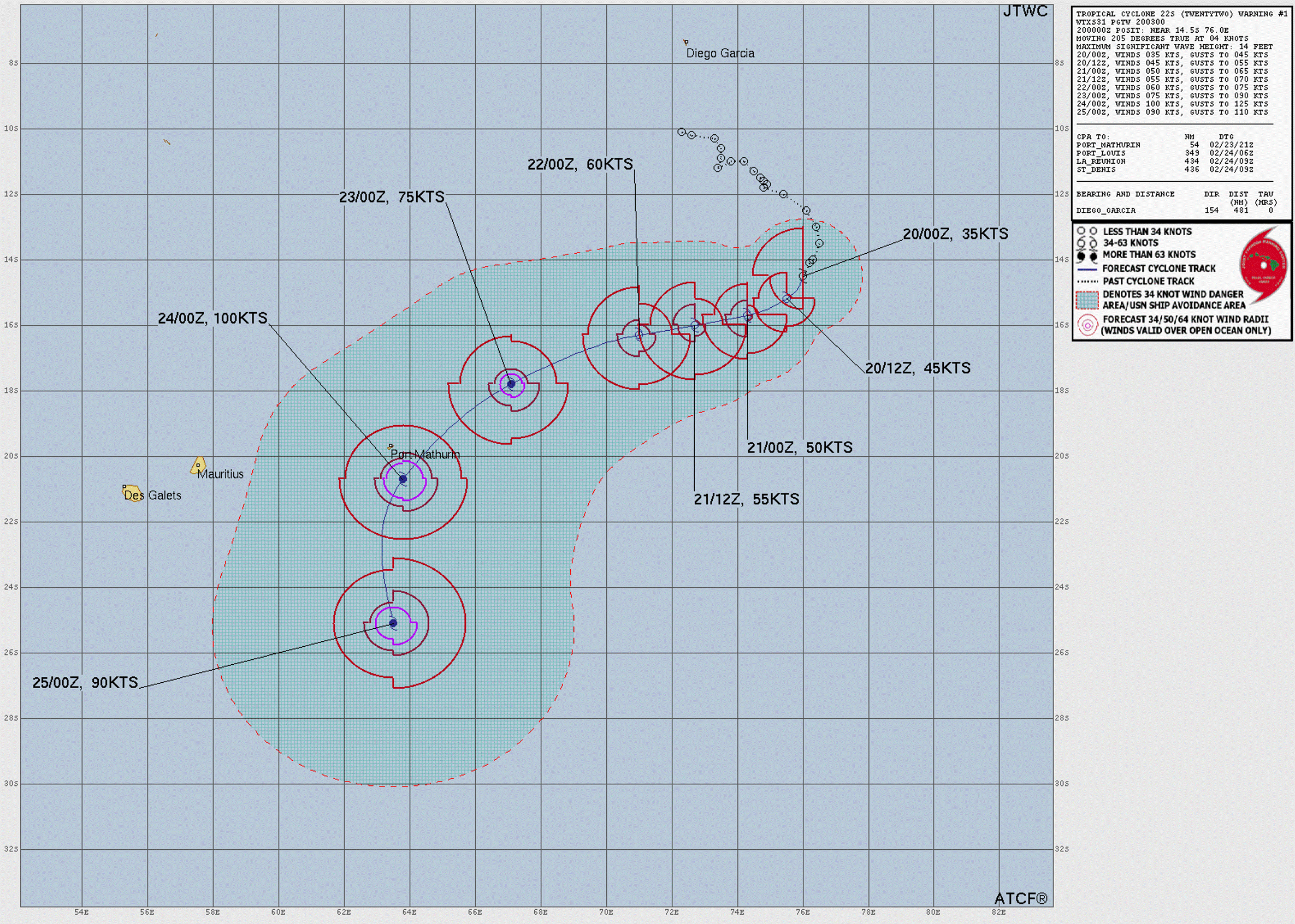
Hurricane HUMBERTO
Updated October 01, 2025 at 06:00 UTC
Located at 35.4°N, 68.2°W
Minimum Pressure: 979 mb
Maximum Winds: 70 kt
Radius of Maximum Wind: 30 nm
Environmental Pressure: 1003 mb
Storm Radius: 140 nm
Formerly Invest 93L
Current Conditions
Latest Satellite Image
Wind Radii
Sea Temperatures
CRW - Mean CRW - Anomaly OISST - Mean OISST - Anomaly TCHP - Mean TCHP - Anomaly
NRL 34/37 GHz Microwave Imagery
2025-09-30 23:17:00 UTC 2025-09-30 21:58:01 UTC 2025-09-30 21:06:00 UTC 2025-09-30 19:31:00 UTC 2025-09-30 17:28:45 UTC 2025-09-30 11:19:28 UTC 2025-09-30 10:38:59 UTC 2025-09-30 06:28:11 UTC
NRL 89 GHz Microwave Imagery
2025-10-01 01:06:05 UTC 2025-09-30 21:58:01 UTC 2025-09-30 21:06:00 UTC 2025-09-30 17:28:45 UTC 2025-09-30 15:25:31 UTC 2025-09-30 11:19:28 UTC 2025-09-30 10:38:59 UTC 2025-09-30 06:28:11 UTC
Forecasts
Latest Model Track Guidance
Forecast Tracks Forecast Tracks & SST Forecast Tracks/Wind OFCL Track Trend TVCN Track Trend HCCA Track Trend GEFS Pressure GEFS Wind EPS Pressure EPS Wind
Latest Model Intensity Guidance
Forecast Wind GEFS Forecast Wind EPS Forecast Wind
Official Forecast
Latest SHIPS Forecast (click for bigger)
Storm History
Storm Track
Raw Data
Pressure and Wind History
Tropical Storm OCTAVE
Updated October 01, 2025 at 06:00 UTC
Located at 10.9°N, 114.6°W
Minimum Pressure: 996 mb
Maximum Winds: 50 kt
Radius of Maximum Wind: 15 nm
Environmental Pressure: 1009 mb
Storm Radius: 150 nm
Formerly Invest 98E
Current Conditions
Latest Satellite Image
Wind Radii
Sea Temperatures
CRW - Mean CRW - Anomaly OISST - Mean OISST - Anomaly TCHP - Mean TCHP - Anomaly
NRL 34/37 GHz Microwave Imagery
2025-10-01 02:35:00 UTC 2025-10-01 01:45:00 UTC 2025-10-01 01:14:12 UTC 2025-09-30 22:48:00 UTC 2025-09-30 20:40:11 UTC 2025-09-30 14:20:21 UTC 2025-09-30 14:08:59 UTC 2025-09-30 09:51:58 UTC
NRL 89 GHz Microwave Imagery
2025-10-01 01:14:12 UTC 2025-09-30 20:40:11 UTC 2025-09-30 17:00:53 UTC 2025-09-30 14:20:21 UTC 2025-09-30 14:08:59 UTC 2025-09-30 09:51:58 UTC
Forecasts
Latest Model Track Guidance
Forecast Tracks Forecast Tracks & SST Forecast Tracks/Wind OFCL Track Trend TVCN Track Trend HCCA Track Trend GEFS Pressure GEFS Wind EPS Pressure EPS Wind
Latest Model Intensity Guidance
Forecast Wind GEFS Forecast Wind EPS Forecast Wind
Official Forecast
Latest SHIPS Forecast (click for bigger)
Storm History
Storm Track
Raw Data
Pressure and Wind History
Tropical Storm ONE
Updated October 01, 2025 at 06:00 UTC
Located at 15.9°N, 86.5°E
Minimum Pressure: 997 mb
Maximum Winds: 35 kt
Radius of Maximum Wind: N/A nm
Environmental Pressure: N/A mb
Storm Radius: N/A nm
Current Conditions
Latest Satellite Image
Wind Radii
Sea Temperatures
CRW - Mean CRW - Anomaly OISST - Mean OISST - Anomaly TCHP - Mean TCHP - Anomaly
Forecasts
Official Forecast
Storm History
Storm Track
Raw Data
Pressure and Wind History
Tropical Depression 90A
Updated October 01, 2025 at 06:00 UTC
Located at 22.0°N, 68.6°E
Minimum Pressure: 997 mb
Maximum Winds: 25 kt
Current Conditions
Latest Satellite Image
Sea Temperatures
CRW - Mean CRW - Anomaly OISST - Mean OISST - Anomaly TCHP - Mean TCHP - Anomaly
NRL 34/37 GHz Microwave Imagery
2025-10-01 02:27:00 UTC 2025-10-01 01:55:38 UTC 2025-10-01 01:35:00 UTC 2025-10-01 01:15:05 UTC 2025-09-30 23:30:00 UTC 2025-09-30 21:20:45 UTC 2025-09-30 13:27:22 UTC 2025-09-30 09:11:09 UTC
NRL 89 GHz Microwave Imagery
2025-10-01 01:55:38 UTC 2025-10-01 01:15:05 UTC 2025-09-30 21:20:45 UTC 2025-09-30 17:00:53 UTC 2025-09-30 15:25:31 UTC 2025-09-30 13:27:22 UTC 2025-09-30 09:11:09 UTC 2025-09-30 05:50:13 UTC
Storm History
Storm Track
Raw Data
Pressure and Wind History
Tropical Depression TWENTYSEVE
Updated October 01, 2025 at 06:00 UTC
Located at 14.7°N, 130.8°E
Minimum Pressure: 1006 mb
Maximum Winds: 25 kt
Radius of Maximum Wind: N/A nm
Environmental Pressure: N/A mb
Storm Radius: N/A nm
Current Conditions
Latest Satellite Image
Sea Temperatures
CRW - Mean CRW - Anomaly OISST - Mean OISST - Anomaly TCHP - Mean TCHP - Anomaly
Forecasts
Official Forecast
Storm History
Storm Track
Raw Data
Pressure and Wind History
This page uses data from the National Hurricane Center (NHC) and Joint Typhoon Warning Center (JTWC), with best track files through the Automated Tropical Cyclone Forecast (ATCF) system. Microwave imagery courtesy of the U.S. Naval Research Laboratory.