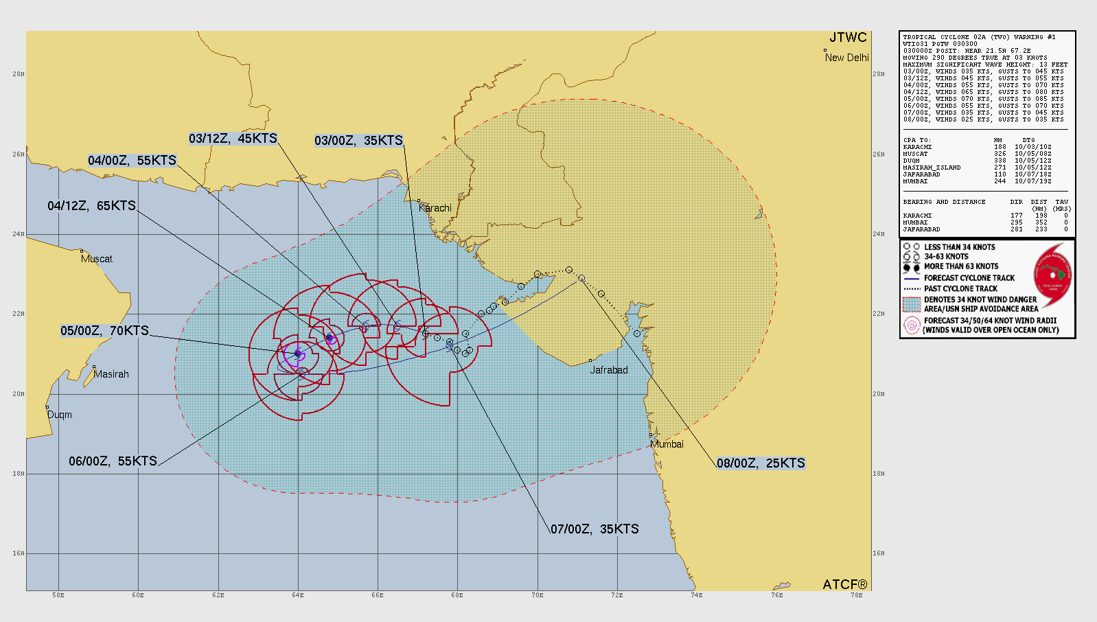
Tropical Storm SHAKHTI
Updated October 03, 2025 at 12:00 UTC
Located at 22°N, 66.4°E
Minimum Pressure: 995 mb
Maximum Winds: 45 kt
Radius of Maximum Wind: 50 nm
Environmental Pressure: 1008 mb
Storm Radius: 185 nm
Current Conditions
Latest Satellite Image
Wind Radii
Sea Temperatures
CRW - Mean CRW - Anomaly OISST - Mean OISST - Anomaly TCHP - Mean TCHP - Anomaly
NRL 34/37 GHz Microwave Imagery
2025-10-03 11:18:58 UTC 2025-10-03 08:03:46 UTC 2025-10-03 01:25:28 UTC 2025-10-03 01:15:22 UTC
NRL 89 GHz Microwave Imagery
2025-10-03 11:18:58 UTC 2025-10-03 08:03:45 UTC 2025-10-03 06:21:26 UTC 2025-10-03 01:25:28 UTC 2025-10-03 01:15:25 UTC
Forecasts
Latest Model Track Guidance
EPS Pressure EPS Wind
Latest Model Intensity Guidance
EPS Forecast Wind
Official Forecast
Storm History
Storm Track
Raw Data
Pressure and Wind History
Tropical Storm MATMO
Updated October 03, 2025 at 12:00 UTC
Located at 17.5°N, 119.4°E
Minimum Pressure: 993 mb
Maximum Winds: 60 kt
Radius of Maximum Wind: 30 nm
Environmental Pressure: 1010 mb
Storm Radius: 165 nm
Current Conditions
Latest Satellite Image
Wind Radii
Sea Temperatures
CRW - Mean CRW - Anomaly OISST - Mean OISST - Anomaly TCHP - Mean TCHP - Anomaly
NRL 34/37 GHz Microwave Imagery
2025-10-03 09:03:14 UTC 2025-10-03 08:13:58 UTC 2025-10-03 04:43:59 UTC 2025-10-02 21:54:03 UTC 2025-10-02 17:52:12 UTC 2025-10-02 09:22:31 UTC
NRL 89 GHz Microwave Imagery
2025-10-03 09:03:14 UTC 2025-10-03 08:13:58 UTC 2025-10-03 04:43:59 UTC 2025-10-03 01:28:02 UTC 2025-10-02 21:54:03 UTC 2025-10-02 17:52:12 UTC 2025-10-02 09:22:31 UTC
Forecasts
Official Forecast
Storm History
Storm Track
Raw Data
Pressure and Wind History
Tropical Storm OCTAVE
Updated October 03, 2025 at 12:00 UTC
Located at 13.3°N, 120.7°W
Minimum Pressure: 1001 mb
Maximum Winds: 45 kt
Radius of Maximum Wind: 40 nm
Environmental Pressure: 1011 mb
Storm Radius: 250 nm
Formerly Invest 98E
Current Conditions
Latest Satellite Image
Wind Radii
Sea Temperatures
CRW - Mean CRW - Anomaly OISST - Mean OISST - Anomaly TCHP - Mean TCHP - Anomaly
NRL 34/37 GHz Microwave Imagery
2025-10-03 13:50:16 UTC 2025-10-03 02:15:55 UTC 2025-10-03 00:28:58 UTC 2025-10-02 13:28:05 UTC
NRL 89 GHz Microwave Imagery
2025-10-03 13:50:16 UTC 2025-10-03 04:44:33 UTC 2025-10-03 02:15:55 UTC 2025-10-03 00:28:58 UTC 2025-10-02 17:22:06 UTC 2025-10-02 13:28:05 UTC
Forecasts
Latest Model Track Guidance
Forecast Tracks Forecast Tracks & SST Forecast Tracks/Wind OFCL Track Trend TVCN Track Trend HCCA Track Trend GEFS Pressure GEFS Wind EPS Pressure EPS Wind
Latest Model Intensity Guidance
Forecast Wind GEFS Forecast Wind EPS Forecast Wind
Official Forecast
Latest SHIPS Forecast (click for bigger)
Storm History
Storm Track
Raw Data
Pressure and Wind History
Tropical Depression ONE
Updated October 03, 2025 at 00:00 UTC
Located at 21.2°N, 83.7°E
Minimum Pressure: 996 mb
Maximum Winds: 30 kt
Radius of Maximum Wind: N/A nm
Environmental Pressure: N/A mb
Storm Radius: N/A nm
Current Conditions
Latest Satellite Image
Sea Temperatures
CRW - Mean CRW - Anomaly OISST - Mean OISST - Anomaly TCHP - Mean TCHP - Anomaly
NRL 34/37 GHz Microwave Imagery
2025-10-03 01:15:29 UTC 2025-10-02 23:52:09 UTC 2025-10-02 19:29:56 UTC 2025-10-02 12:46:31 UTC
NRL 89 GHz Microwave Imagery
2025-10-03 04:44:33 UTC 2025-10-03 01:15:29 UTC 2025-10-02 23:52:09 UTC 2025-10-02 19:29:56 UTC 2025-10-02 15:46:39 UTC 2025-10-02 12:46:31 UTC
Forecasts
Latest Model Track Guidance
EPS Pressure EPS Wind
Latest Model Intensity Guidance
EPS Forecast Wind
Official Forecast
Storm History
Storm Track
Raw Data
Pressure and Wind History
Invest 94W
Updated October 03, 2025 at 12:00 UTC
Located at 21.6°N, 144.7°E
Minimum Pressure: 1011 mb
Maximum Winds: 20 kt
Current Conditions
Latest Satellite Image
Sea Temperatures
CRW - Mean CRW - Anomaly OISST - Mean OISST - Anomaly TCHP - Mean TCHP - Anomaly
NRL 34/37 GHz Microwave Imagery
2025-10-03 07:22:32 UTC 2025-10-03 06:39:56 UTC 2025-10-03 03:05:55 UTC 2025-10-02 20:11:42 UTC
NRL 89 GHz Microwave Imagery
2025-10-03 07:22:32 UTC 2025-10-03 06:39:56 UTC 2025-10-03 03:05:55 UTC 2025-10-02 23:49:15 UTC 2025-10-02 20:11:42 UTC
Storm History
Storm Track
Raw Data
Pressure and Wind History
This page uses data from the National Hurricane Center (NHC) and Joint Typhoon Warning Center (JTWC), with best track files through the Automated Tropical Cyclone Forecast (ATCF) system. Microwave imagery courtesy of the U.S. Naval Research Laboratory.