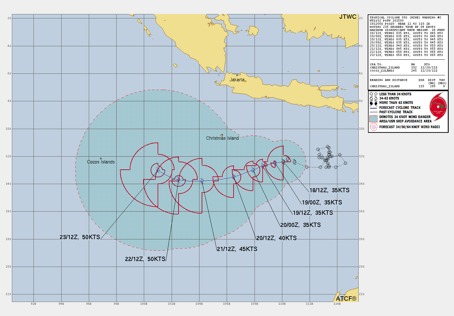
Current Storms:

Tropical Storm NINE

Updated December 18, 2025 at 18:00 UTC

00z Update Coming Soon

Located at 12.2°S, 109.2°E

Minimum Pressure: 999 mb

Maximum Winds: 35 kt

Radius of Maximum Wind: 30 nm

Environmental Pressure: 1005 mb

Storm Radius: 200 nm

Current Conditions

Latest Satellite Image Latest satellite image for Tropical Storm NINE
Wind RadiiWind radii for Tropical Storm NINE
Sea Temperatures Sea surface temperature map for Tropical Storm NINE
NRL 34/37 GHz Microwave Imagery NRL color34 imagery for Tropical Storm NINE
NRL 89 GHz Microwave Imagery NRL 89H imagery for Tropical Storm NINE

Advertisement

Forecasts

Official Forecast Official forecast cone for Tropical Storm NINE

Advertisement

Storm History

Storm Track Historical track for Tropical Storm NINE Raw Data
Pressure and Wind History Pressure and wind history for Tropical Storm NINE

Tropical Depression BAKUNG

Updated December 18, 2025 at 06:00 UTC

Located at 10.1°S, 91.8°E

Minimum Pressure: 1004 mb

Maximum Winds: 25 kt

Radius of Maximum Wind: 70 nm

Environmental Pressure: 1009 mb

Storm Radius: 130 nm

Current Conditions

Latest Satellite Image Latest satellite image for Tropical Depression BAKUNG
Sea Temperatures Sea surface temperature map for Tropical Depression BAKUNG
NRL 34/37 GHz Microwave Imagery NRL color34 imagery for Tropical Depression BAKUNG
NRL 89 GHz Microwave Imagery NRL 89H imagery for Tropical Depression BAKUNG

Advertisement

Forecasts

Latest Model Track Guidance Latest model track guidance for Tropical Depression BAKUNG
Latest Model Intensity Guidance Latest model intensity guidance for Tropical Depression BAKUNG
Official Forecast Official forecast cone for Tropical Depression BAKUNG

Advertisement

Storm History

Storm Track Historical track for Tropical Depression BAKUNG Raw Data
Pressure and Wind History Pressure and wind history for Tropical Depression BAKUNG

Invest 95S

Updated December 18, 2025 at 06:00 UTC

Located at 9.7°S, 136.5°E

Minimum Pressure: 1006 mb

Maximum Winds: 15 kt

Current Conditions

Latest Satellite Image Latest satellite image for Invest 95S
Sea Temperatures Sea surface temperature map for Invest 95S
NRL 34/37 GHz Microwave Imagery NRL color34 imagery for Invest 95S
NRL 89 GHz Microwave Imagery NRL 89H imagery for Invest 95S

Advertisement

Storm History

Storm Track Historical track for Invest 95S Raw Data
Pressure and Wind History Pressure and wind history for Invest 95S

This page uses data from the National Hurricane Center (NHC) and Joint Typhoon Warning Center (JTWC), with best track files through the Automated Tropical Cyclone Forecast (ATCF) system. Microwave imagery courtesy of the U.S. Naval Research Laboratory.