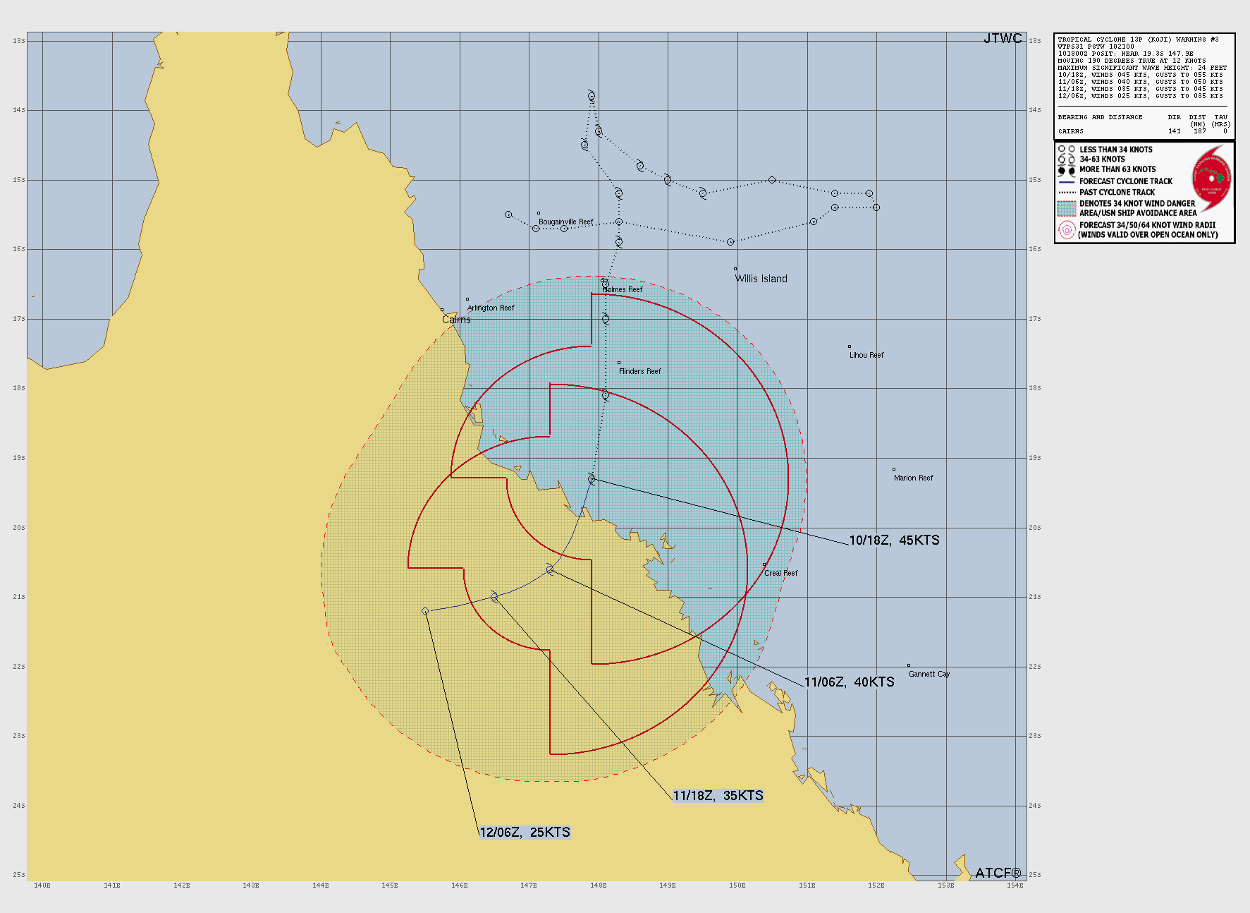
Tropical Depression KOJI
Updated January 11, 2026 at 06:00 UTC
Located at 20.7°S, 147.3°E
Minimum Pressure: 993 mb
Maximum Winds: 30 kt
Radius of Maximum Wind: 60 nm
Environmental Pressure: 998 mb
Storm Radius: 120 nm
Formerly Invest 92P
Current Conditions
Latest Satellite Image
Sea Temperatures
CRW - Mean CRW - Anomaly OISST - Mean OISST - Anomaly TCHP - Mean TCHP - Anomaly
NRL 34/37 GHz Microwave Imagery
2026-01-11 04:09:22 UTC 2026-01-11 02:49:43 UTC 2026-01-10 20:34:18 UTC 2026-01-10 19:12:00 UTC 2026-01-10 18:11:00 UTC 2026-01-10 15:58:32 UTC
NRL 89 GHz Microwave Imagery
2026-01-11 04:09:22 UTC 2026-01-11 02:49:43 UTC 2026-01-10 20:34:18 UTC 2026-01-10 15:58:31 UTC
Forecasts
Latest Model Track Guidance
Forecast Tracks Forecast Tracks & SST Forecast Tracks/Wind JTWC Track Trend GEFS Pressure GEFS Wind EPS Pressure EPS Wind
Latest Model Intensity Guidance
Forecast Wind GEFS Forecast Wind EPS Forecast Wind
Official Forecast
Storm History
Storm Track
Raw Data
Pressure and Wind History
Tropical Storm DUDZAI
Updated January 11, 2026 at 06:00 UTC
Located at 15°S, 77°E
Minimum Pressure: 994 mb
Maximum Winds: 55 kt
Radius of Maximum Wind: 15 nm
Environmental Pressure: 1010 mb
Storm Radius: 160 nm
Formerly Invest 93S
Current Conditions
Latest Satellite Image
Wind Radii
Sea Temperatures
CRW - Mean CRW - Anomaly OISST - Mean OISST - Anomaly TCHP - Mean TCHP - Anomaly
NRL 34/37 GHz Microwave Imagery
2026-01-10 23:56:15 UTC 2026-01-10 23:15:00 UTC 2026-01-10 20:53:52 UTC 2026-01-10 14:45:00 UTC
NRL 89 GHz Microwave Imagery
2026-01-10 23:56:15 UTC 2026-01-10 20:53:52 UTC
Forecasts
Latest Model Track Guidance
Forecast Tracks Forecast Tracks & SST Forecast Tracks/Wind GEFS Pressure GEFS Wind
Latest Model Intensity Guidance
Forecast Wind GEFS Forecast Wind
Official Forecast
Storm History
Storm Track
Raw Data
Pressure and Wind History
Remnants of JENNA
Updated January 11, 2026 at 06:00 UTC
Located at 19.4°S, 79°E
Minimum Pressure: 1008 mb
Maximum Winds: 20 kt
Radius of Maximum Wind: 30 nm
Environmental Pressure: 0 mb
Storm Radius: 0 nm
Formerly Invest 91S
Current Conditions
Latest Satellite Image
Sea Temperatures
CRW - Mean CRW - Anomaly OISST - Mean OISST - Anomaly TCHP - Mean TCHP - Anomaly
NRL 34/37 GHz Microwave Imagery
2026-01-11 07:29:05 UTC 2026-01-10 23:57:01 UTC 2026-01-10 23:16:00 UTC 2026-01-10 19:16:28 UTC 2026-01-10 18:05:47 UTC 2026-01-10 12:47:07 UTC
NRL 89 GHz Microwave Imagery
2026-01-11 07:29:05 UTC 2026-01-10 23:57:01 UTC 2026-01-10 19:16:28 UTC 2026-01-10 18:05:47 UTC 2026-01-10 12:47:07 UTC
Forecasts
Latest Model Track Guidance
Forecast Tracks Forecast Tracks & SST Forecast Tracks/Wind JTWC Track Trend GEFS Pressure GEFS Wind EPS Pressure EPS Wind
Latest Model Intensity Guidance
Forecast Wind GEFS Forecast Wind EPS Forecast Wind
Official Forecast
Storm History
Storm Track
Raw Data
Pressure and Wind History
Invest 90B
Updated January 10, 2026 at 18:00 UTC
Located at 9.8°N, 79.8°E
Minimum Pressure: 1010 mb
Maximum Winds: 20 kt
Radius of Maximum Wind: 45 nm
Environmental Pressure: 0 mb
Storm Radius: 0 nm
Current Conditions
Latest Satellite Image
Sea Temperatures
CRW - Mean CRW - Anomaly OISST - Mean OISST - Anomaly TCHP - Mean TCHP - Anomaly
NRL 34/37 GHz Microwave Imagery
2026-01-10 12:55:09 UTC
NRL 89 GHz Microwave Imagery
2026-01-10 12:55:09 UTC
Forecasts
Latest Model Track Guidance
Forecast Tracks Forecast Tracks & SST Forecast Tracks/Wind GEFS Pressure GEFS Wind
Latest Model Intensity Guidance
Forecast Wind GEFS Forecast Wind
Official Forecast
Storm History
Storm Track
Raw Data
Pressure and Wind History
Invest 94P
Updated January 11, 2026 at 06:00 UTC
Located at 15.5°S, 161.1°E
Minimum Pressure: 1002 mb
Maximum Winds: 15 kt
Current Conditions
Latest Satellite Image
Sea Temperatures
CRW - Mean CRW - Anomaly OISST - Mean OISST - Anomaly TCHP - Mean TCHP - Anomaly
NRL 34/37 GHz Microwave Imagery
2026-01-11 07:23:30 UTC 2026-01-11 01:14:56 UTC 2026-01-10 19:10:00 UTC 2026-01-10 18:51:55 UTC
NRL 89 GHz Microwave Imagery
2026-01-11 07:23:30 UTC 2026-01-11 01:14:56 UTC 2026-01-10 18:51:55 UTC
Storm History
Storm Track
Raw Data
Pressure and Wind History
This page uses data from the National Hurricane Center (NHC) and Joint Typhoon Warning Center (JTWC), with best track files through the Automated Tropical Cyclone Forecast (ATCF) system. Microwave imagery courtesy of the U.S. Naval Research Laboratory.