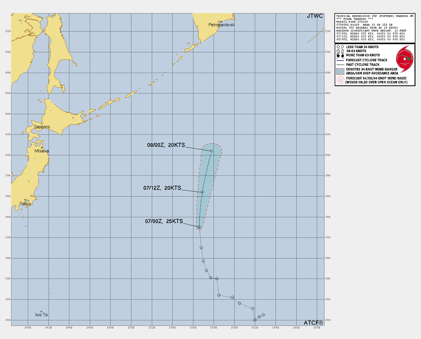
Remnants of FIFTEEN
Updated August 07, 2025 at 12:00 UTC
Located at 35.8°N, 156.8°E
Minimum Pressure: 1008 mb
Maximum Winds: 20 kt
Radius of Maximum Wind: 40 nm
Environmental Pressure: 0 mb
Storm Radius: 0 nm
Formerly Invest 97W
Current Conditions
Latest Satellite Image
Sea Temperatures
CRW - Mean CRW - Anomaly OISST - Mean OISST - Anomaly TCHP - Mean TCHP - Anomaly Subsurface Profile
Forecasts
Latest Model Track Guidance
Forecast Tracks Forecast Tracks & SST Forecast Tracks/Wind JTWC Track Trend GEFS Pressure GEFS Wind
Latest Model Intensity Guidance
Forecast Wind GEFS Forecast Wind
Official Forecast
Storm History
Storm Track
Raw Data
Pressure and Wind History
Remnants of DEXTER
Updated August 07, 2025 at 12:00 UTC
Located at 41°N, 51.4°W
Minimum Pressure: 998 mb
Maximum Winds: 50 kt
Radius of Maximum Wind: 70 nm
Environmental Pressure: 1019 mb
Storm Radius: 240 nm
Formerly Invest 95L
Current Conditions
Latest Satellite Image
Wind Radii
Sea Temperatures
CRW - Mean CRW - Anomaly OISST - Mean OISST - Anomaly TCHP - Mean TCHP - Anomaly Subsurface Profile
Forecasts
Latest Model Track Guidance
Forecast Tracks Forecast Tracks & SST Forecast Tracks/Wind OFCL Track Trend TVCN Track Trend GEFS Pressure GEFS Wind EPS Pressure EPS Wind
Latest Model Intensity Guidance
Forecast Wind GEFS Forecast Wind EPS Forecast Wind
Official Forecast
Latest SHIPS Forecast (click for bigger)
Storm History
Storm Track
Raw Data
Pressure and Wind History
Tropical Storm HENRIETTE
Updated August 07, 2025 at 12:00 UTC
Located at 18.5°N, 134.8°W
Minimum Pressure: 1004 mb
Maximum Winds: 45 kt
Radius of Maximum Wind: 30 nm
Environmental Pressure: 1015 mb
Storm Radius: 120 nm
Formerly Invest 90E
Current Conditions
Latest Satellite Image
Wind Radii
Sea Temperatures
CRW - Mean CRW - Anomaly OISST - Mean OISST - Anomaly TCHP - Mean TCHP - Anomaly Subsurface Profile
Forecasts
Latest Model Track Guidance
Forecast Tracks Forecast Tracks & SST Forecast Tracks/Wind OFCL Track Trend TVCN Track Trend GEFS Pressure GEFS Wind EPS Pressure EPS Wind
Latest Model Intensity Guidance
Forecast Wind GEFS Forecast Wind EPS Forecast Wind
Official Forecast
Latest SHIPS Forecast (click for bigger)
Storm History
Storm Track
Raw Data
Pressure and Wind History
Tropical Storm IVO
Updated August 07, 2025 at 12:00 UTC
Located at 17.3°N, 103.3°W
Minimum Pressure: 1006 mb
Maximum Winds: 40 kt
Radius of Maximum Wind: 10 nm
Environmental Pressure: 1012 mb
Storm Radius: 90 nm
Formerly Invest 91E
Current Conditions
Latest Satellite Image
Latest Radar Image
Wind Radii
Sea Temperatures
CRW - Mean CRW - Anomaly OISST - Mean OISST - Anomaly TCHP - Mean TCHP - Anomaly Subsurface Profile
Nearby METAR Stations
Choose a station MMAA MMIA MMPN MMZO
Pressure
Temperature
Wind Speed
Wind Direction
Forecasts
Latest Model Track Guidance
Forecast Tracks Forecast Tracks & SST Forecast Tracks/Wind OFCL Track Trend TVCN Track Trend GEFS Pressure GEFS Wind EPS Pressure EPS Wind
Latest Model Intensity Guidance
Forecast Wind GEFS Forecast Wind EPS Forecast Wind
Official Forecast
Latest SHIPS Forecast (click for bigger)
Storm History
Storm Track
Raw Data
Pressure and Wind History
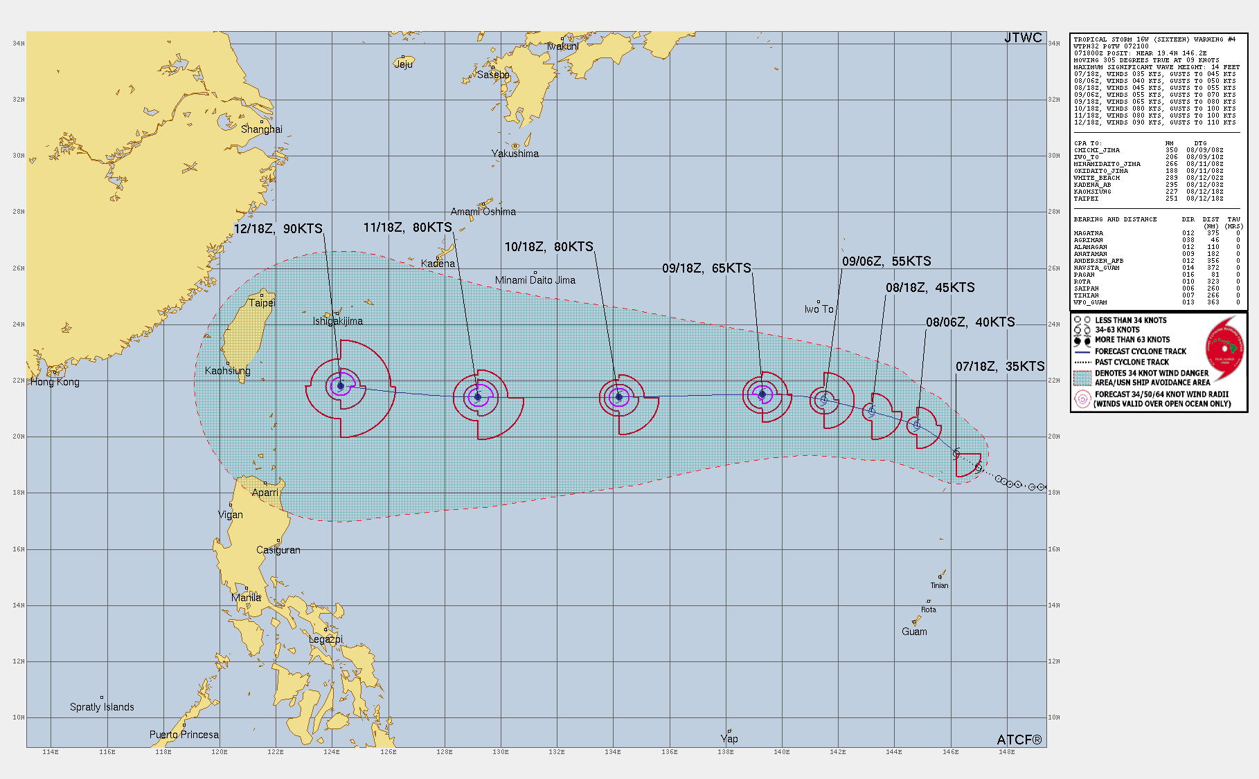
Tropical Storm SIXTEEN
Updated August 07, 2025 at 12:00 UTC
Located at 19°N, 147°E
Minimum Pressure: 1005 mb
Maximum Winds: 35 kt
Radius of Maximum Wind: 20 nm
Environmental Pressure: 1012 mb
Storm Radius: 135 nm
Formerly Invest 98W
Current Conditions
Latest Satellite Image
Wind Radii
Sea Temperatures
CRW - Mean CRW - Anomaly OISST - Mean OISST - Anomaly TCHP - Mean TCHP - Anomaly Subsurface Profile
Forecasts
Latest Model Track Guidance
Forecast Tracks Forecast Tracks & SST Forecast Tracks/Wind JTWC Track Trend GEFS Pressure GEFS Wind
Latest Model Intensity Guidance
Forecast Wind GEFS Forecast Wind
Official Forecast
Storm History
Storm Track
Raw Data
Pressure and Wind History
Tropical Storm AWO
Updated August 07, 2025 at 12:00 UTC
Located at 7.1°S, 60.8°E
Minimum Pressure: 1002 mb
Maximum Winds: 35 kt
Radius of Maximum Wind: 40 nm
Environmental Pressure: 1007 mb
Storm Radius: 150 nm
Formerly Invest 91S
Current Conditions
Latest Satellite Image
Wind Radii
Sea Temperatures
CRW - Mean CRW - Anomaly OISST - Mean OISST - Anomaly TCHP - Mean TCHP - Anomaly Subsurface Profile
Forecasts
Latest Model Track Guidance
Forecast Tracks Forecast Tracks & SST Forecast Tracks/Wind JTWC Track Trend GEFS Pressure GEFS Wind EPS Pressure EPS Wind
Latest Model Intensity Guidance
Forecast Wind GEFS Forecast Wind EPS Forecast Wind
Official Forecast
Storm History
Storm Track
Raw Data
Pressure and Wind History
Invest 96W
Updated August 07, 2025 at 12:00 UTC
Located at 17.8°N, 119.6°E
Minimum Pressure: 1008 mb
Maximum Winds: 15 kt
Current Conditions
Latest Satellite Image
Latest Radar Image
Sea Temperatures
CRW - Mean CRW - Anomaly OISST - Mean OISST - Anomaly TCHP - Mean TCHP - Anomaly Subsurface Profile
Nearby METAR Stations
Choose a station RPLC RPLI RPLL
Pressure
Temperature
Wind Speed
Wind Direction
Storm History
Storm Track
Raw Data
Pressure and Wind History
This page uses data from the National Hurricane Center (NHC) and Joint Typhoon Warning Center (JTWC), with best track files through the Automated Tropical Cyclone Forecast (ATCF) system. Microwave imagery courtesy of the U.S. Naval Research Laboratory.