Typhoon RAGASA
Updated September 21, 2025 at 00:00 UTC
Located at 17.9°N, 127°E
Minimum Pressure: 933 mb
Maximum Winds: 120 kt
Radius of Maximum Wind: 5 nm
Environmental Pressure: 1006 mb
Storm Radius: 240 nm
Current Conditions
Latest Satellite Image
Wind Radii
Sea Temperatures
CRW - Mean CRW - Anomaly OISST - Mean OISST - Anomaly TCHP - Mean TCHP - Anomaly
34/37 GHz Microwave Imagery
2025-09-20 22:49:00 UTC 2025-09-20 22:04:00 UTC 2025-09-20 20:51:39 UTC 2025-09-20 17:26:57 UTC 2025-09-20 11:04:52 UTC 2025-09-20 10:01:57 UTC 2025-09-20 09:30:00 UTC 2025-09-20 08:21:17 UTC 2025-09-20 05:14:55 UTC
89 GHz Microwave Imagery
2025-09-21 00:55:04 UTC 2025-09-20 20:51:39 UTC 2025-09-20 17:26:57 UTC 2025-09-20 12:03:38 UTC 2025-09-20 11:04:52 UTC 2025-09-20 10:01:57 UTC 2025-09-20 08:21:17 UTC 2025-09-20 05:14:54 UTC 2025-09-20 00:44:05 UTC
Forecasts
Latest Model Track Guidance
EPS Pressure EPS Wind
Latest Model Intensity Guidance
EPS Forecast Wind
Official Forecast
Storm History
Storm Track
Raw Data
Pressure and Wind History
Remnants of MITAG
Updated September 21, 2025 at 00:00 UTC
Located at 23.6°N, 111.5°E
Minimum Pressure: 1007 mb
Maximum Winds: 15 kt
Radius of Maximum Wind: N/A nm
Environmental Pressure: N/A mb
Storm Radius: N/A nm
Current Conditions
Latest Satellite Image
Sea Temperatures
CRW - Mean CRW - Anomaly OISST - Mean OISST - Anomaly TCHP - Mean TCHP - Anomaly
34/37 GHz Microwave Imagery
2025-09-21 02:02:12 UTC 2025-09-20 22:47:00 UTC 2025-09-20 22:28:59 UTC 2025-09-20 22:03:00 UTC 2025-09-20 20:45:00 UTC 2025-09-20 12:37:18 UTC 2025-09-20 10:03:41 UTC 2025-09-20 09:32:00 UTC 2025-09-20 05:16:46 UTC
89 GHz Microwave Imagery
2025-09-21 02:02:12 UTC 2025-09-20 22:28:59 UTC 2025-09-20 13:39:22 UTC 2025-09-20 12:37:18 UTC 2025-09-20 10:03:43 UTC 2025-09-20 05:16:46 UTC 2025-09-20 02:23:25 UTC
Forecasts
Latest Model Track Guidance
EPS Pressure EPS Wind
Latest Model Intensity Guidance
EPS Forecast Wind
Official Forecast
Storm History
Storm Track
Raw Data
Pressure and Wind History
Tropical Storm GABRIELLE
Updated September 21, 2025 at 00:00 UTC
Located at 25.9°N, 59°W
Minimum Pressure: 996 mb
Maximum Winds: 55 kt
Radius of Maximum Wind: 15 nm
Environmental Pressure: 1013 mb
Storm Radius: 180 nm
Formerly Invest 92L
Current Conditions
Latest Satellite Image
Wind Radii
Sea Temperatures
CRW - Mean CRW - Anomaly OISST - Mean OISST - Anomaly TCHP - Mean TCHP - Anomaly
34/37 GHz Microwave Imagery
2025-09-20 23:28:01 UTC 2025-09-20 22:10:00 UTC 2025-09-20 21:54:15 UTC 2025-09-20 21:26:00 UTC 2025-09-20 16:49:23 UTC 2025-09-20 13:37:20 UTC 2025-09-20 10:09:00 UTC 2025-09-20 05:53:06 UTC
89 GHz Microwave Imagery
2025-09-21 00:55:04 UTC 2025-09-20 23:28:01 UTC 2025-09-20 21:54:15 UTC 2025-09-20 16:49:23 UTC 2025-09-20 13:39:22 UTC 2025-09-20 13:37:20 UTC 2025-09-20 05:53:06 UTC 2025-09-20 00:44:05 UTC
Forecasts
Latest Model Track Guidance
Forecast Tracks Forecast Tracks & SST Forecast Tracks/Wind OFCL Track Trend TVCN Track Trend HCCA Track Trend GEFS Pressure GEFS Wind EPS Pressure EPS Wind
Latest Model Intensity Guidance
Forecast Wind GEFS Forecast Wind EPS Forecast Wind
Official Forecast
Latest SHIPS Forecast (click for bigger)
Storm History
Storm Track
Raw Data
Pressure and Wind History
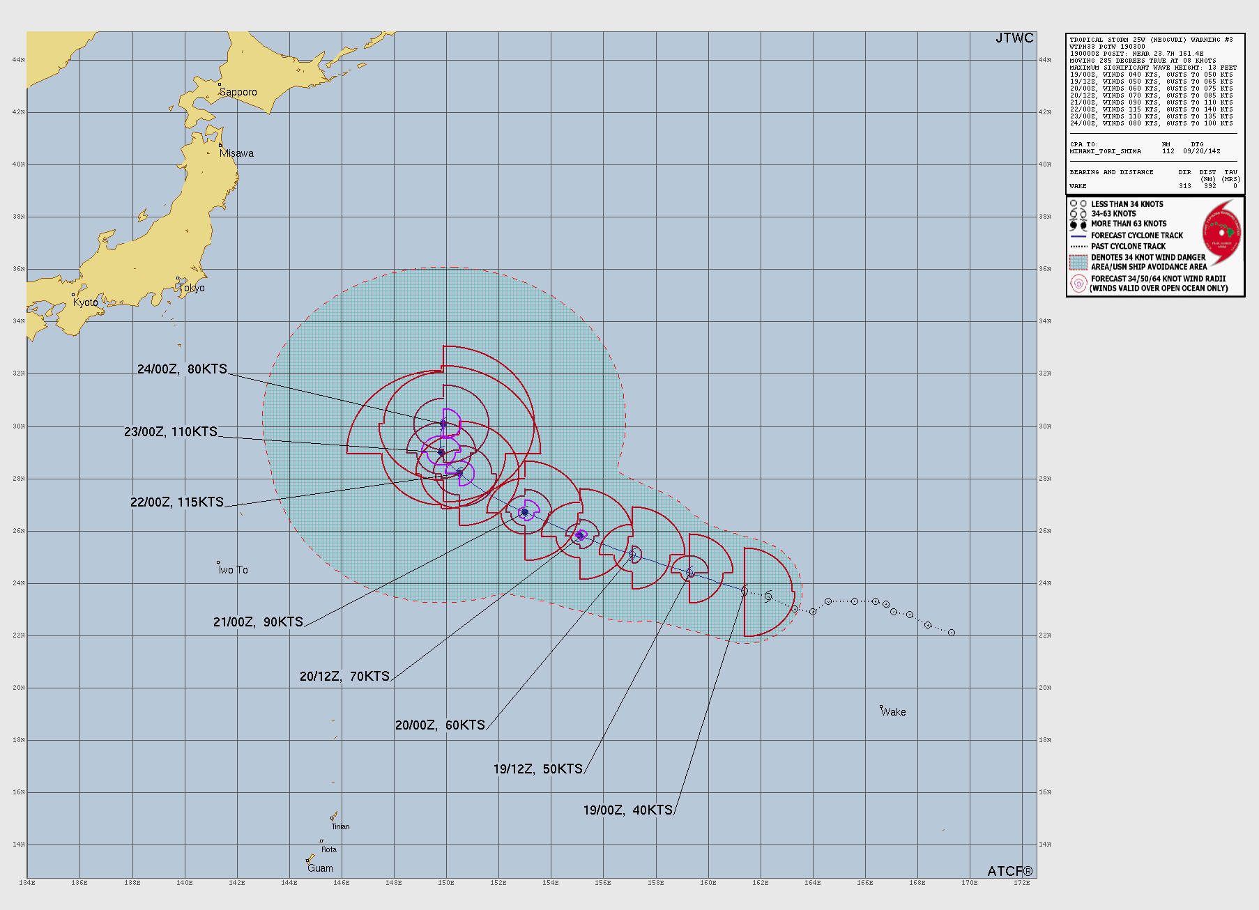
Typhoon NEOGURI
Updated September 21, 2025 at 00:00 UTC
Located at 27.2°N, 152.7°E
Minimum Pressure: 936 mb
Maximum Winds: 125 kt
Radius of Maximum Wind: 12 nm
Environmental Pressure: 1011 mb
Storm Radius: 210 nm
Current Conditions
Latest Satellite Image
Wind Radii
Sea Temperatures
CRW - Mean CRW - Anomaly OISST - Mean OISST - Anomaly TCHP - Mean TCHP - Anomaly
34/37 GHz Microwave Imagery
2025-09-20 22:56:49 UTC 2025-09-20 20:20:00 UTC 2025-09-20 17:21:00 UTC 2025-09-20 15:45:35 UTC 2025-09-20 09:28:55 UTC 2025-09-20 07:51:00 UTC 2025-09-20 06:41:43 UTC 2025-09-20 06:13:00 UTC
89 GHz Microwave Imagery
2025-09-20 22:56:49 UTC 2025-09-20 15:45:35 UTC 2025-09-20 10:27:40 UTC 2025-09-20 09:28:55 UTC 2025-09-20 06:41:43 UTC
Forecasts
Official Forecast
Storm History
Storm Track
Raw Data
Pressure and Wind History
Invest 92W
Updated September 21, 2025 at 00:00 UTC
Located at 8.1°N, 141°E
Minimum Pressure: 1011 mb
Maximum Winds: 30 kt
Current Conditions
Latest Satellite Image
Sea Temperatures
CRW - Mean CRW - Anomaly OISST - Mean OISST - Anomaly TCHP - Mean TCHP - Anomaly
34/37 GHz Microwave Imagery
2025-09-20 22:51:27 UTC 2025-09-20 21:09:00 UTC 2025-09-20 20:53:46 UTC 2025-09-20 20:25:00 UTC 2025-09-20 15:50:38 UTC
89 GHz Microwave Imagery
2025-09-20 22:51:27 UTC 2025-09-20 20:53:46 UTC 2025-09-20 15:50:38 UTC
Storm History
Storm Track
Raw Data
Pressure and Wind History
Invest 98B
Updated September 21, 2025 at 00:00 UTC
Located at 17.4°N, 93.2°E
Minimum Pressure: 1006 mb
Maximum Winds: 15 kt
Current Conditions
Latest Satellite Image
Sea Temperatures
CRW - Mean CRW - Anomaly OISST - Mean OISST - Anomaly TCHP - Mean TCHP - Anomaly
34/37 GHz Microwave Imagery
2025-09-21 03:34:51 UTC 2025-09-21 00:30:00 UTC 2025-09-21 00:14:04 UTC 2025-09-20 23:46:00 UTC 2025-09-20 22:29:00 UTC 2025-09-20 19:06:22 UTC 2025-09-20 11:12:00 UTC
89 GHz Microwave Imagery
2025-09-21 03:34:51 UTC 2025-09-21 00:14:04 UTC 2025-09-20 19:06:22 UTC 2025-09-20 15:14:53 UTC
Storm History
Storm Track
Raw Data
Pressure and Wind History
This page uses data from the National Hurricane Center (NHC) and Joint Typhoon Warning Center (JTWC), with best track files through the Automated Tropical Cyclone Forecast (ATCF) system. Microwave imagery courtesy of the U.S. Naval Research Laboratory.