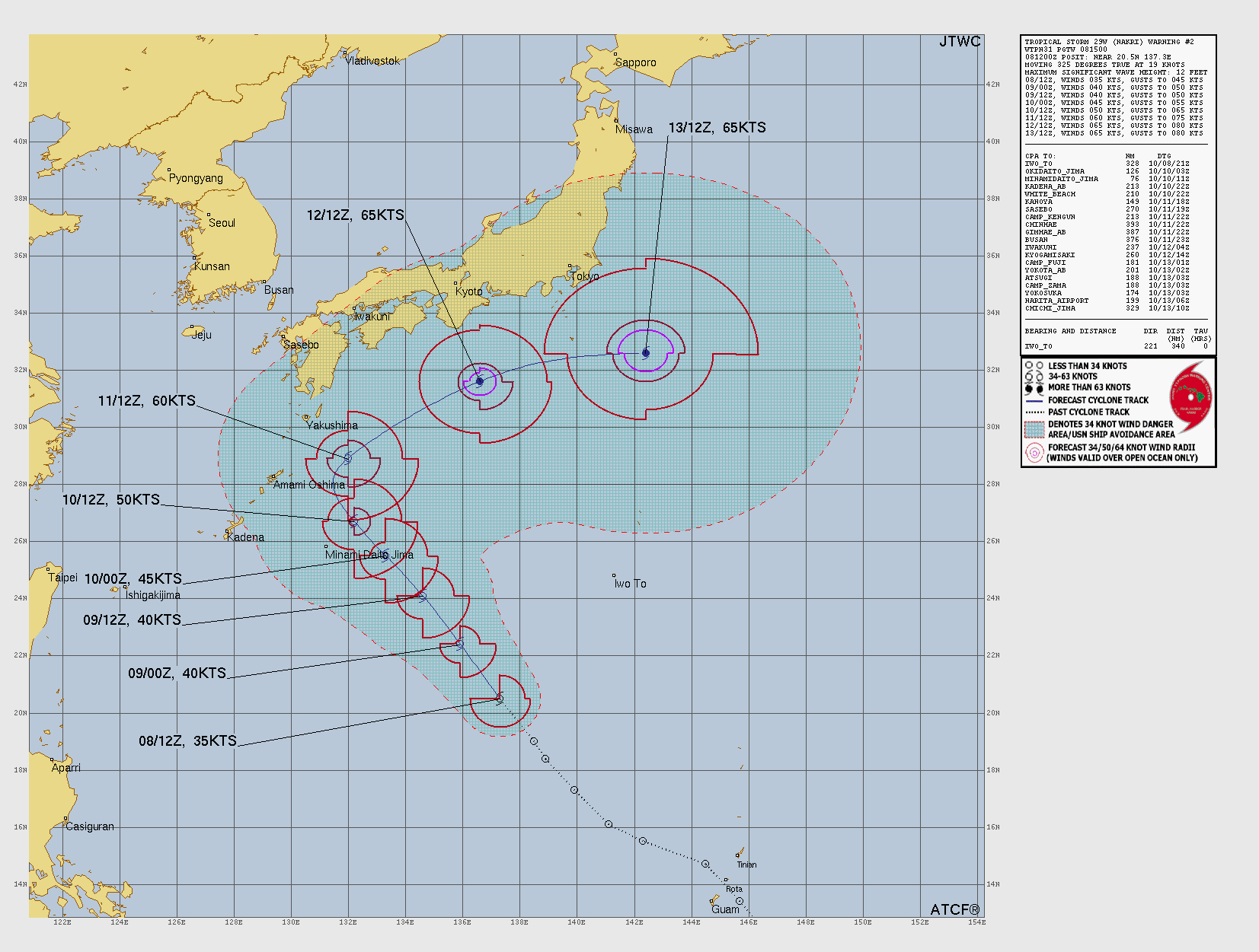
Tropical Storm NAKRI
Updated October 08, 2025 at 18:00 UTC
Located at 21.8°N, 136.3°E
Minimum Pressure: 1000 mb
Maximum Winds: 40 kt
Radius of Maximum Wind: 30 nm
Environmental Pressure: 1008 mb
Storm Radius: 130 nm
Current Conditions
Latest Satellite Image
Wind Radii
Sea Temperatures
CRW - Mean CRW - Anomaly OISST - Mean OISST - Anomaly TCHP - Mean TCHP - Anomaly
NRL 34/37 GHz Microwave Imagery
2025-10-08 19:46:08 UTC 2025-10-08 17:13:30 UTC 2025-10-08 09:04:00 UTC
NRL 89 GHz Microwave Imagery
2025-10-08 19:46:08 UTC 2025-10-08 17:13:30 UTC 2025-10-08 09:04:00 UTC
Forecasts
Official Forecast
Storm History
Storm Track
Raw Data
Pressure and Wind History
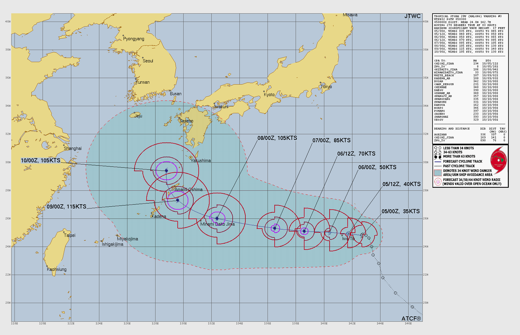
Typhoon HALONG
Updated October 08, 2025 at 18:00 UTC
Located at 32.5°N, 139.4°E
Minimum Pressure: 946 mb
Maximum Winds: 110 kt
Radius of Maximum Wind: 15 nm
Environmental Pressure: 1010 mb
Storm Radius: 215 nm
Current Conditions
Latest Satellite Image
Wind Radii
Sea Temperatures
CRW - Mean CRW - Anomaly OISST - Mean OISST - Anomaly TCHP - Mean TCHP - Anomaly
NRL 34/37 GHz Microwave Imagery
2025-10-08 19:49:17 UTC 2025-10-08 17:10:30 UTC 2025-10-08 09:07:19 UTC 2025-10-08 04:43:42 UTC 2025-10-08 03:27:26 UTC 2025-10-07 21:48:59 UTC
NRL 89 GHz Microwave Imagery
2025-10-08 19:49:17 UTC 2025-10-08 17:10:30 UTC 2025-10-08 09:07:22 UTC 2025-10-08 04:43:42 UTC 2025-10-08 03:27:26 UTC 2025-10-08 00:44:11 UTC 2025-10-07 21:48:59 UTC 2025-10-07 11:53:04 UTC
Forecasts
Official Forecast
Storm History
Storm Track
Raw Data
Pressure and Wind History
Tropical Storm PRISCILLA
Updated October 08, 2025 at 18:00 UTC
Located at 21.7°N, 112.7°W
Minimum Pressure: 985 mb
Maximum Winds: 60 kt
Radius of Maximum Wind: 40 nm
Environmental Pressure: 1008 mb
Storm Radius: 200 nm
Formerly Invest 99E
Current Conditions
Latest Satellite Image
Wind Radii
Sea Temperatures
CRW - Mean CRW - Anomaly OISST - Mean OISST - Anomaly TCHP - Mean TCHP - Anomaly
NRL 34/37 GHz Microwave Imagery
2025-10-08 13:06:11 UTC 2025-10-08 08:59:17 UTC 2025-10-08 00:37:24 UTC 2025-10-07 22:34:29 UTC 2025-10-07 20:49:01 UTC
NRL 89 GHz Microwave Imagery
2025-10-08 13:06:11 UTC 2025-10-08 08:59:17 UTC 2025-10-08 00:37:24 UTC 2025-10-07 22:34:29 UTC 2025-10-07 20:49:01 UTC
Forecasts
Latest Model Track Guidance
Forecast Tracks Forecast Tracks & SST Forecast Tracks/Wind OFCL Track Trend TVCN Track Trend HCCA Track Trend GEFS Pressure GEFS Wind EPS Pressure EPS Wind
Latest Model Intensity Guidance
Forecast Wind GEFS Forecast Wind EPS Forecast Wind
Official Forecast
Latest SHIPS Forecast (click for bigger)
Storm History
Storm Track
Raw Data
Pressure and Wind History
Tropical Storm JERRY
Updated October 08, 2025 at 18:00 UTC
Located at 14.4°N, 53.8°W
Minimum Pressure: 1000 mb
Maximum Winds: 50 kt
Radius of Maximum Wind: 50 nm
Environmental Pressure: 1009 mb
Storm Radius: 120 nm
Formerly Invest 95L
Current Conditions
Latest Satellite Image
Wind Radii
Sea Temperatures
CRW - Mean CRW - Anomaly OISST - Mean OISST - Anomaly TCHP - Mean TCHP - Anomaly
NRL 34/37 GHz Microwave Imagery
2025-10-08 18:48:38 UTC 2025-10-08 16:33:50 UTC 2025-10-08 09:45:30 UTC 2025-10-08 07:16:25 UTC 2025-10-07 21:12:07 UTC
NRL 89 GHz Microwave Imagery
2025-10-08 18:48:38 UTC 2025-10-08 16:33:50 UTC 2025-10-08 09:45:30 UTC 2025-10-08 07:16:25 UTC 2025-10-07 21:12:07 UTC
Forecasts
Latest Model Track Guidance
Forecast Tracks Forecast Tracks & SST Forecast Tracks/Wind OFCL Track Trend TVCN Track Trend HCCA Track Trend GEFS Pressure GEFS Wind EPS Pressure EPS Wind
Latest Model Intensity Guidance
Forecast Wind GEFS Forecast Wind EPS Forecast Wind
Official Forecast
Latest SHIPS Forecast (click for bigger)
Storm History
Storm Track
Raw Data
Pressure and Wind History
Tropical Storm OCTAVE
Updated October 08, 2025 at 18:00 UTC
Located at 15.5°N, 115.8°W
Minimum Pressure: 1003 mb
Maximum Winds: 35 kt
Radius of Maximum Wind: 30 nm
Environmental Pressure: 1008 mb
Storm Radius: 100 nm
Formerly Invest 98E
Current Conditions
Latest Satellite Image
Wind Radii
Sea Temperatures
CRW - Mean CRW - Anomaly OISST - Mean OISST - Anomaly TCHP - Mean TCHP - Anomaly
NRL 34/37 GHz Microwave Imagery
2025-10-08 11:56:42 UTC 2025-10-08 09:00:57 UTC 2025-10-08 02:17:16 UTC 2025-10-07 22:35:22 UTC 2025-10-07 20:47:46 UTC
NRL 89 GHz Microwave Imagery
2025-10-08 11:56:42 UTC 2025-10-08 09:00:57 UTC 2025-10-08 05:38:30 UTC 2025-10-08 02:17:16 UTC 2025-10-07 22:35:22 UTC 2025-10-07 20:47:46 UTC
Forecasts
Latest Model Track Guidance
Forecast Tracks Forecast Tracks & SST Forecast Tracks/Wind OFCL Track Trend TVCN Track Trend HCCA Track Trend GEFS Pressure GEFS Wind EPS Pressure EPS Wind
Latest Model Intensity Guidance
Forecast Wind GEFS Forecast Wind EPS Forecast Wind
Official Forecast
Latest SHIPS Forecast (click for bigger)
Storm History
Storm Track
Raw Data
Pressure and Wind History
Remnants of SHAKHTI
Updated October 08, 2025 at 18:00 UTC
Located at 18.4°N, 61.5°E
Minimum Pressure: 1004 mb
Maximum Winds: 20 kt
Radius of Maximum Wind: N/A nm
Environmental Pressure: N/A mb
Storm Radius: N/A nm
Current Conditions
Latest Satellite Image
Sea Temperatures
CRW - Mean CRW - Anomaly OISST - Mean OISST - Anomaly TCHP - Mean TCHP - Anomaly
NRL 34/37 GHz Microwave Imagery
2025-10-08 14:08:03 UTC 2025-10-08 11:01:20 UTC 2025-10-08 08:21:33 UTC 2025-10-08 01:17:14 UTC 2025-10-07 23:31:52 UTC 2025-10-07 21:27:38 UTC
NRL 89 GHz Microwave Imagery
2025-10-08 14:08:03 UTC 2025-10-08 11:01:20 UTC 2025-10-08 08:21:33 UTC 2025-10-08 05:38:30 UTC 2025-10-08 01:17:14 UTC 2025-10-07 23:31:52 UTC 2025-10-07 21:27:38 UTC
Forecasts
Latest Model Track Guidance
EPS Pressure EPS Wind
Latest Model Intensity Guidance
EPS Forecast Wind
Official Forecast
Storm History
Storm Track
Raw Data
Pressure and Wind History
This page uses data from the National Hurricane Center (NHC) and Joint Typhoon Warning Center (JTWC), with best track files through the Automated Tropical Cyclone Forecast (ATCF) system. Microwave imagery courtesy of the U.S. Naval Research Laboratory.